Garmin (NYSE: GRMN) today announced Federal Aviation Administration (FAA) certification of Garmin Autoland and Garmin Autothrottle for select G1000® NXi-equipped King Air 350 aircraft1. The full Autothrottle integration with the G1000 NXi integrated flight deck reduces crew workload in the cockpit by managing aircraft speed and power and provides engine protection against potential exceedances. In the event of an emergency where the crew can no longer perform their duties, Garmin Autoland can control and land the aircraft without human intervention2. This is particularly important for single pilot operations, or to add an additional layer of safety for two pilot operations.
“Nearly 1,000 King Air operators now enjoy the capabilities that the G1000 upgrade has provided them. This announcement adds a direct pathway to Autothrottle and Autoland equipage for many of those aircraft. This certification also marks the largest airplane to date equipped with Autoland, and is the eleventh aircraft model certified with this potentially life-saving technology. It’s just the beginning.” Carl Wolf, Vice President Aviation Sales, Marketing, Programs & Support
Garmin Autothrottle
Garmin’s Autothrottle, certified for select King Air 300 and 350 aircraft3, provides extensive safety-enhancing features and greatly reduces workload in the busy King Air cockpit. Autothrottle is fully integrated with the G1000 NXi system and provides automatic control of the engine power levers from takeoff to landing. Autothrottle keeps power levers in the proper power setting, negating the threat of a possible throttle rollback. Power settings are based on manufacturer or user-configurable climb, cruise, and descent schedules, including ITT limits. Additionally, Garmin Autothrottle provides ITT and torque protection by reducing power when the system senses potential overtemperature or overtorque conditions and takes into account flap and gear position when managing airspeed limitations. Full G1000 NXi system integration also allows Garmin Autothrottle to follow FMS speed constraints on departure and arrival procedures.

Market Forecasts (By Region, Fitment, Sub System, and End-User), Scenario Analysis, Opportunity Analysis, and Leading Company Profiles
Download free sample pages More informationFurther assisting the crew in high-workload scenarios, Autothrottle will also activate automatically in the event of an aircraft overspeed or underspeed situation, providing additional redundancy for pilots operating the aircraft. If Autothrottle detects an engine failure, it automatically sets the power lever on the failed side to a fixed position and adjusts the operative throttle lever to maintain the selected airspeed reference.
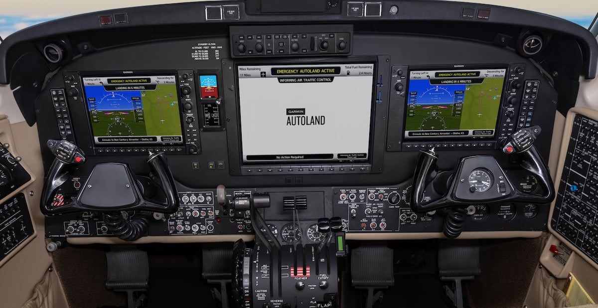
Garmin Autoland
Whether flying for business or pleasure, a pilot’s top priority is keeping everyone safe. Now there is a way to provide even more protection in select King Air 350 aircraft: the award-winning Garmin Autoland system. Autoland determines the most optimal airport and runway, considering factors such as weather, fuel on board, runway surface and length, terrain, obstacles and more. In the event of an emergency, pilots or passengers can activate Autoland by the press of a button, located in the back of the center pedestal for easy access. Autoland will activate automatically if the system determines it’s necessary.
Once activated, the system calculates a flight path to the most suitable available airport, initiates an approach to the runway and automatically lands the aircraft. The system takes into consideration a breadth of information and criteria and will automatically communicate with air traffic control (ATC) throughout the entire event, advising controllers and pilots operating near the aircraft of its location and intentions.
Throughout an Autoland activation, the system provides simple visual and verbal communications in plain language, so passengers have the information and know what to expect. The flight displays show the aircraft’s location on a map alongside information such as the destination airport, estimated time enroute, distance to the destination airport and fuel remaining. Airspeed, altitude and aircraft heading are labeled in an easy-to-understand format and passengers also have the option to communicate with ATC by following instructions on the multi-function display.
During an Autoland activation, the Garmin Autothrottle system is used to automatically manage aircraft speed and engine power so the aircraft can climb, descend or maintain altitude as needed. If temperatures are conducive to ice accumulation, Autoland activates anti-ice and deice systems for the engines and control surfaces. On approach to landing, the system initiates a controlled descent to the airport. If the aircraft needs additional time to descend or slow down during the approach, the Autoland system initiates a standard holding procedure. Once Autoland configures the landing gear and flaps, the aircraft begins its descent to the runway and lands. On the runway, automatic braking is applied while tracking the runway centerline to bring the aircraft to a complete stop. Engine shutdown is also automated so occupants can safely exit the aircraft.
Additional G1000 NXi Features
With the latest upgrade, King Air 300 and 350 aircraft equipped with G1000 NXi can take advantage of additional Garmin features. Synthetic Vision Technology (SVT™) now includes a 3D exocentric view of the SafeTaxi® airport environment to aid situational awareness while taxiing. SVT also displays 3D building footprints including hangars, terminals and towers, taxiways, aprons, signs and other markings to help reduce runway incursions by providing guidance while taxiing at airports contained in the SafeTaxi database. These SVT updates also increase topographical clarity, sharpened water and terrain boundaries, improved obstacle and powerlines display, enhanced runway and airport sign depiction and more. Also part of Garmin’s Terminal Safety Solutions, Runway Occupancy Awareness (ROA) uses ADS-B traffic to alert the crew of potential runway incursions caused by nearby airborne aircraft, aircraft on the ground and ground vehicles.
Adding on to Garmin’s revolutionary electronic stability and protection (ESP™) technology, one engine inoperative ESP assists the pilot in maintaining control in the event of a single engine failure. ESP pitch and roll limits will adjust to prevent excessive pitch or bank angles while the pilot performs single engine procedures.
The GWX™ 8000 StormOptix™ weather radar simplifies operations and brings peace of mind to single-pilot and crewed aircraft while operating in and near complex weather. Auto Mode lets pilots simply set the range, and the radar automatically adjusts tilt and gain settings to accurately profile weather cells, so pilots can analyze returns from hazardous storm cell activity. The system displays the weather with 16 colors while also showcasing hail and lightning prediction, turbulence detection and advanced ground clutter suppression.
Additionally, FAA Data Comm allows the flight crew to communicate more clearly via text-based communications with air traffic control. Pilots can receive departure clearances at over 60 airports, as well as enroute clearances, frequency changes and more at all US enroute air traffic control centers while flying above 16,000 feet in the United States.